
Sent from my Verizon Wireless BlackBerry
Friday, July 31, 2009
Halfway, OR
Sent from my Verizon Wireless BlackBerry
Richland, OR to Brownlee Reservoir, ID
Via Hwys 86 and 71. 47 miles. After a long, steep climb out of Richland we gradually dropped down into a beautiful valley on our way into Hells Canyon. We stopped for breakfast and to load up on food for the next few days* at Halfway, OR, a neat little town that sits at the foot of a magnificent set of mountain peaks. We found Devon in front of the grocery store loading up yogurts and other disgustingly healthy stuff** (she had left Richland about 25 minutes ahead of us). She took off again while we did our grocery shopping and went in search of a cafe.
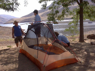
We then rode down into Hells Canyon, formed by the flow of the Snake River. By the time we hit the canyon floor the temperature was in the 90s although it was still before noon. We rode up and past the first of two dams at Oxbow and continued up the Oregon side of the river canyon to Brownlee Dam. There we stopped on the shade of a tree at a company town for workers at the nearby hydroelectric plant. Two of the workers stopped and asked us if we needed water or anything else. When we told them of our plans to ride up out of the canyon tomorrow morning one of the guys offered to drive us out in his pickup truck to eliminate the very tough climb. We thanked them, resumed riding across the dam and river into Idaho where we again ran into Devon again. There is a nice campground at Brownlee Dam, operated by Idaho Power Company, but the three of us decided to continue on up river on the Idaho side to another Idaho Power camp site that is closer to the start of the climb out of the canyon which we'll tackle early tomorrow morning. Those last few miles were difficult as it was uphill and the heat was intense. But we took a break where we could find a little shade and rolled into the second campground about 2:30 in the afternoon,*** before the temperature peaked over 100 degrees. We found a great camp site in the tent area, mainly because there wasn't another soul in the tent area. Every other camper was huddled inside his/her RV with the air conditioner full on. We went into the tent about 9:30 and laid on top of our sleeping bags in our underwear sweating like mad. It finally cooled off enough about midnight and we ended up getting a pretty decent night's sleep.
*There is no place to eat or buy food after you pass a small store outside of Oxbow until after you are out of the canyon again.
**She is a vegetarian but seems OK hanging around with two carnivores.
***We crossed from the Pacific into the Mountain Time zone at the border.
Halfway, OR

Sent from my Verizon Wireless BlackBerry


Hells Canyon pic #4

Sent from my Verizon Wireless BlackBerry


Chatting with Sam, the camp host
Sent from my Verizon Wireless BlackBerry
Wednesday, July 29, 2009
Baker City to Richland, OR
Via Hwy 86. 42 miles. As you can tell, it is taking us a long time to cross Oregon. Today's route took us along part of the Oregon Trail, a path taken by the pioneers in wagons and no roads over 100 years ago. I have a new appreciation for those people. We have good roads, good equipment (bikes), cell phones, GPS, etc., etc., and still it is hard work crossing this arid landscape. How the early settlers managed it just boggles the mind. They obviously wanted a new start real bad.
We did a relatively short ride again today. We are trying to best position ourselves to hit the passes early in the morning before it gets really hot. If we had gone further east today we would have had a 1,000 foot climb out of Richland in the afternoon heat. (It is 92 degrees outside at 3 pm as I am writing this.) Instead, we will do it tomorrow morning when the temperature is cooler. And the day after tomorrow we face a similar situation, a 2,000 foot very, very steep climb out of the Snake River canyon. Temperatures on the canyon floor can reach 110 degrees during the day, so we plan to ride a little over 40 miles tomorrow to a campsite near the bottom of the climb so that we are crawling upward on the Mother of All Climbs on Friday morning rather than tomorrow afternoon.
We met up with Devon again in Richland and agreed to share the cost of a motel room (at the Hitching Post, it ain't fancy but it is air conditioned). We again saw quite a few west-bound riders. We chatted with several, including a guy who told us that a day behind him is a couple on a recumbent three-wheeled tandem pulling a trailer. We can't wait to meet them and, in true guy fashion, compare the size of our rigs!
Sent from my Verizon Wireless BlackBerry
Downtown Richland

Sent from my Verizon Wireless BlackBerry
Roadside marker commemorating landslide

Sent from my Verizon Wireless BlackBerry
Scenery between Baker City and Richland

Sent from my Verizon Wireless BlackBerry
Oregon Trail Interpretive Center

Sent from my Verizon Wireless BlackBerry

Tuesday, July 28, 2009
Sumpter to Baker City, OR
Via Hwys 220 and 7. 30 miles.
We wanted a "recovery day" after two hard days in a row, so today's relatively short ride along the Powder River valley, involving mostly downhill or flat terrain, fit the bill perfectly. We slept in this morning* and took our time getting going, which was a great way to ease back into spending time on the bike.
As it turned out, we were glad that we had a short day to deal with some unexpected mechanical problems. Shortly after leaving Sumpter, the drive chain became jammed in the front derailleur. The chain somehow became doubled up inside the derailleur, which I have never had happen before on any bike or even seen happen before. We managed to dislodge it, but in the process pushed the derailleur out of ideal alignment. We re-aligned the derailleur as best we could and were still able to shift. But we were limited to using the middle and granny rings (i.e., not the big ring). Then after a few more miles we heard a loud flapping coming from the rear wheel. We discovered that the tire tread was completely separating from the casing - the tire was "all done runnin'" as they say.** So we pulled over, found a shady spot and began the ritual*** of changing the rear tire (we were carrying one spare tire), a process that takes a good hour. While we were working 2 different couples, one traveling by motorcycle and one by car, stopped to ask if we needed any help. We were really touched by their kindness. It also reminded us of many similar experiences we had on the eastern leg of our trip and on our Colorado-to-Minnesota trip several years ago.
So we needed to find a bike shop when we arrived in Baker City to have the front derailleur properly aligned and pick up a new spare tire. There are 2 bike shops in town, which is a good thing because we had to visit both to get what we needed. By the time we finished that, ate lunch and found a store that carried the energy bars we prefer (Clif Bars) it was very hot out. So we were glad to be done with further riding for the day.
A good thing that happened today is that we caught up with Devon again. She took a rest day here today (we took ours in Mitchell, several days earlier) so we are back on the same schedule. We had dinner with her and may together tomorrow and perhaps for days thereafter.
*We spent the night in a really nice cabin behind the Scoop 'N' Steamer cafe/ice cream parlor in Sumpter. It had a king-sized bed and it was air conditioned!
**We later realized that the rear tire had remained unchanged since we were in Pontiac, Illinois on the first part of our trip. Thus we had over 1,700 miles on it, almost double the mileage we had gotten out of any other rear tire. The trailer and our weight place a tremendous load on the rear tire, which wears many times faster than the front tire.
***Detach the trailer, remove the panniers, GPS and computer and turn the bike upside down. Then disengage the drum brake and rear caliper brake and loosen the quick release skewer. Remove the rear wheel, deflate the tire, (using tire levers) remove the old tire, replace the tube, mount and inflate the new tire. Then put everything back together again.
Sent from my Verizon Wireless BlackBerry


John Day to Sumpter, OR
Via Hwy 26 to Austin Junction, Hwy 7 to Sumpter Junction and Hwy 220 into Sumpter. 58.2 miles.
It was a pretty remarkable day. In crossing the Blue Mountain range we rode over 3 steep mountain passes, representing a total elevation gain of 3,600 feet. The grades were so steep that most of the way up we were crawling along in our next-to-lowest gear* at 4 mph, and we had the brakes on full almost all the way down the descents. We got a fairly late start out of John Day** and thus hit the first pass (Dixie) as the sun well up in the sky, causing us to get very toasty. Fortunately the temperature cooled off in the afternoon so the heat was not a major factor on the last two passes.
We stopped for lunch at the cafe/store in Austin Junction*** after the Dixie Pass descent. There were at least a half-dozen cyclists in the parking lot, sleeping or resting in the shade. They looked really tired and grungy, and reminded me of Mel Gibson and the other characters riding motorcycles across the Australian outback in the aftermath of world nuclear war in The Road Warrior (one of all-time my favorite trash movies). Later, Carlos confirmed (see below) that those guys had not enjoyed a shower for a couple of weeks, but said he loved traveling with them as they "were hilarious traveling companions."
The Austin Junction cafe had guitar instrumental music playing while we were at lunch, which I originally thought was really nice. But we quickly realized it was the same song over and over and over again - "Hail, Hail the Gang's All Here". The woman who ran the place and who served us appeared to be oblivious to the constant repetition of the same song. In contrast, we were both filled more with nausea than nutrition by the time we were finished.
We met up again with the cyclist from LA (Paul) and learned that he plans to ride through Colorado Springs on his way home (in early September). We invited him to stay at our home that evening, an offer he really seemed to appreciate.
We also met Carlos, another east-to-west cyclist. He and his friend Joe are traveling from New Jersey to Portland, OR. They are also writing a blog and had a set of "business cards" made up in conjunction with their trip. Carlos asked if we'd seen 6 grungy guys and one grungy gal traveling together and we filled him in on our stop at the store. Carlos had a bad crash about a week ago and was still pretty skinned up, but like almost all the riders we've met on this trip, was upbeat and not deterred from moving on to his destination.
*For years some of my riding buddies have teased me because for a long time I have been using triple cranksets with very small gear ratios on all my bikes.
(You can probably imagine the nature of most of this abuse, relating to me having tiny things. Using such 'weenie gears' has greatly helped save wear and tear on my knees. For self-supported touring and anytime on the tandem small gears are simply essential. So I have just learned to ignore the ridicule and have smugly enjoyed watching those same guys more and more start using a compact crankset, if not a triple). I just consider myself a visionary for being a low gear weenie before it became socially acceptable.
**I failed to mention in yesterday's post that John Day, for whom the town and the river are named, was - in the terminology of the winning (white settler) side of the settling of the area 'an Indian fighter who helped subdue the hostile tribes in the area'.
***I use the word "the" to describe the store/cafe because it is the only thing in Austin Junction. It is the only place on the TransAmerica route to stop for food or water in the 45 mile, 3 mountain pass stretch between Prairie City and Sumpter. It is closed on Tuesdays and Wednesdays, another illustration why you need to plan your ride carefully. If you show up at the store out of water and/or food on the wrong day you are SOL.
Sent from my Verizon Wireless BlackBerry


Another lousy day at the office

Sent from my Verizon Wireless BlackBerry


Sunday, July 26, 2009
Mitchell to John Day, OR
Via Hwy 26. 70.8 miles. We rode a lot farther than we had expected to today, both because we felt good after a day off and the accommodations/food options were very limited between Mitchell and John Day.*
The day began with a steep 7-mile climb out of Mitchell up Keyes Creek Pass. Since we had fresh legs, we ground our way up to the top with relative ease. Despite the fact it was early in the morning and the temperature was still relatively cool, we both shed gallons of sweat by the time we crested the summit however. From there we enjoyed a 25-mile descent into the John Day River canyon and the Picture Gorge.
It was another scorcher today, but for the first time on this part of our trip some clouds rolled in during the afternoon. The cloud cover provided welcome relief from the blazing sun as we rode through the river valley, where cattle and horses grazed in fields flanked by magnificent bluffs.
We saw only one other cyclist today (heading west as we continued east). He waved and went on by so we did not get to hear his story.
We stopped at a C-store just as we hit the John Day city limits for a last break (we were definitely tired). I decided to buy some beer** and they had a 6-pack of Budweiser that was missing one bottle. I knew that we'd never drink an entire 6-pack anyway so I thought I would get myself a deal over the regular $5.79 price for the full 6-pack. But when I took the 5-pack to the counter, the young lady rang up the sale as 5 individual bottles and said I owed $6.75. I pointed out (as patiently as possible, which is tough for me as patience is admittedly not one of my stronger virtues) that since I could buy an entire 6-pack for $5.79, I did not understand why I had to pay more beer for less. She paused a moment to consider that, then magnanimously announced that she would give me the 5 bottles for the same $5.79 price as a 6-pack. When I then asked (the patience meter was nearly on empty at that point) why I should pay the 6-pack price for only 5 beers, she clutched and went into stall mode, gurgling something about perhaps having a full 6-pack in the back of the store. I then knew my quest to get a deal on the 5-pack was going nowhere, so I simply paid the 6-pack price and slunk out of the store.
*We had originally planned to stay in Dayville (31 miles west of here) but the only restaurant in town recently closed. So we were facing another evening eating microwaved C-store pizza and thawing frozen egg sandwiches for breakfast. So we decided to check out the next town (Mount Vernon, 23 miles further east), which had an open cafe and two motels. But Mount Vernon looked really dumpy*** and it was only 8 more miles to John Day, so we plodded on further. Eight miles doesn't sound like much, but as we'd already ridden 52 miles (including another mountain pass) it was a bit of a struggle to finish those last few miles.
**We normally don't drink much beer, but after a long day on the bike nothing tastes better than a cold beer. And there are all those carbohydrates that beer contains. Many cyclists drink beer after a ride on the theory they are simply replacing the carbs burned that day and/or "carbo loading" for the next ride. That's their story and they are sticking to it.
***Mitchell, where we spent our rest day, was dumpy too but in a cool Old West kinda way. Mount Vernon was just a plain dump.
Sent from my Verizon Wireless BlackBerry


Keyes Creek Pass

Sent from my Verizon Wireless BlackBerry


Picture Gorge pic #1

Sent from my Verizon Wireless BlackBerry


Another cyclist we met today

Sent from my Verizon Wireless BlackBerry

Mitchell business district

Sent from my Verizon Wireless BlackBerry
High gas prices keep Mitchell residents at home

Sent from my Verizon Wireless BlackBerry
Prineville to Mitchell, OR
(Ridden on July 24) 49.6 miles via Hwy 26. We had a good day again today. We crossed another pass (Ochoco) but it wasn't nearly as difficult as Santiam. We enjoyed a beautiful descent off the pass until about 5 miles before Mitchell,* where the road turned steeply uphill again. By that time (early afternoon) the temperatures had climbed into the high 80s/low 90s making the last few miles into town very hot ones.
We saw dozens of other cyclists today, virtually all of them headed the other direction to complete the TransAmerica route that they began in Virginia.
The one exception to the westbound flow of riders (other than the guy with the dog, who we're still not sure was for real) is Devon, a young woman who we encountered on our way up Ochoco Pass.** She quit her job in Connecticut as an emergency room nurse to ride the TransAmerica route before she goes to Haiti to work in a clinic there. Devon originally planned to ride with a male cyclist who she hooked up with on the Adventure Cycling website. (People advertise there for traveling companions.) Prior to this trip she had never done any serious cycling and was unable to do much serious training for the trip. Also, they planned to start the trip very late in the season for a cross-country trek. (We began in April, most people start in May or at least by June.) Then, two weeks before she was to fly to the West Coast to begin the trip, her travel companion bailed out on her. You would not blame her for throwing in the towel at that point, but Devon put her head down and set out alone. Because she left from Astoria, in northern Oregon, while we began further south in Florence, she has ridden farther and been on the road longer than us. Devon now concedes that she probably won't make it to Virginia on this trip, but is shooting for Denver where a friend lives. Despite the fact that she already has ridden several hundred miles over very challenging terrain, she
is a obviously nervous about what she has gotten herself into. We tried to convince her that is "over the hump" in having made it this far, and were tremendously impressed by her gumption and determination. We are resting here in Mitchell tomorrow while Devon plans to continue riding. We are nevertheless hopeful that we'll catch up to her down the road, to continue to support her (and keep an eye on her).
*I will blog about Mitchell tomorrow, as it deserves a full blog day coverage by itself.
**We could not believe there was another cyclist slower than us. Devon is slower, but not by much.
Rest day in Mitchell, OR
(July 25th) Sorry for the large backlog of posts and pics - we've had no Internet service for several days.
<<<<<<<<<<<<<<<<<<<<<<<<<
Mitchell, population 138, is one of those places where the old joke "don't blink or you might miss it" applies. The town was established in the 1890s and, based on old photos from that era, looks pretty much like it did back then. There are a couple of houses, a school, post office, several abandoned buildings, an old-timey cafe, grocery store and 12-room hotel. A few tourists stop here on their way to and from the nearby John Day area fossil beds along with some cyclists (most of whom camp in the city park* just down the street from the hotel).
But it is otherwise very quiet. At the moment I am sitting on the front porch of the hotel. I have been here for about an hour and have seen only a handful of cars and other people going by on the main street in town. It's a good place for a rest day though because there is absolutely nothing to do other than journal and read.
The hotel is very quaint but lacks a few modern conveniences, like air conditioning and showers (bathtubs only). And it is run by a young mother who reluctantly took the job** and clearly doesn't like it. We picked up on this right away: can we put the bike in our room?*** (no); can we put it on the porch, or in a storage shed? (no - leave it outside); can we use the hotel's washer and dryer to do a load of our laundry? (no); can we use the hotel's phone?**** (no, you have to the pay phone down the street). You get the picture.
A couple more touring cyclists rolled into town today, including a guy from Scotland and another guy who rode up from his home in the LA area, intends to ride east (like us) on the TransAmerica route, then head back west to his home. He appeared to be at least sixty and said he has ridden across country previously, as well as the West Coast from British Columbia to southern California several times. We thought we might be a little bit special riding a tandem on a cross-country trip, but the owner of the grocery store here told us of a could in their late 70s to early 80s who - for THREE YEARS now - have come through Mitchell riding a loaded tandem on their way across the country. As much as we'd like to believe these folks are making this stuff up, I
don't think that's the case.
*It is very common for small towns to allow cyclists to camp in the city park, where the amenities can range from some (bathroom, water) to none.
**She is the daughter of the owners. She lost her regular job and came back to Mitchell to live with her parents. They told her she was going to have to support herself and her 3 kids, and could do so by living in and running the motel. You learn a lot of personal stuff pretty quickly in a small town, particularly with someone like her dad around (he seems to spend most of his time sitting on the front porch talking to anyone who will listen). He is also the owner of Henry the bear, who is housed in a cage across the street from the hotel. Henry used to belong to the local Boy Scouts but when they could no longer take care of him dad agreed to take over that responsibility, for which I give him a lot of credit. Henry eats a tremendous amount of food every day and needs constant attention (for example, he recently dropped a log on one of his toes and probably broke it).
***It is common practice on bike trips for cyclists to store their bikes in their rooms. For example, in the course of this trip we've only stayed in one other place (hotel in Ordway, CO run by a woman with a similarly dour disposition) where we were not permitted to put the bike in our room.
Thursday, July 23, 2009
Sisters to Prineville, OR
Hwy 126 to Redmond, then secondary roads to Prineville. 42 miles. We bounced back from yesterday's tough ride, thanks in part to a gently rolling route along. The weather was warm but not oppressively hot (at least up to the time we rolled into Prineville). Our route took us further into the central Oregon high desert between the Cascades in the west and the Blue Mountains in the east. The section between Redmond and Prineville, which followed the course of the Crooked River, was particularly nice. A great road surface, virtually no traffic and stunning scenery - mountains, bluffs and picturesque horse ranches. We pretty much forgot about yesterday's grind up Santiam Pass, which is good because we have another pass (Ochoco) to conquer tomorrow.
Prineville was originally established as a railroad center by Irving "Barney" Prine, which is odd because there does not appear to be any tracks here at all, and certainly no current train activity. We toured the local historical museum, which was centered on railroads, logging and the Oregon pioneers. They also had an amazing collection of mouse traps. In addition to the traditional spring-loaded traps,* the early settlers developed a wide variety of bottle traps, "ashtray" traps and even a trap that drowned multiple mice by luring them into a one-way tunnel/tower that ends in a plunge into a water tank.** (I hate rodents, so I really got into this display.)
*I think of myself as somewhat of an authority on mouse traps. We have had a persistent mouse problem at home, and have tried everything on the market to get rid of them (except for a cat, as Penny is allergic to cat dander), including traditional (they are humane, still work well), but can be messy, sticky pads (not humane), plug in electric 'dog whistle' devices (humane, but worthless). Nothing works well 100% of the time, which is why there will always be mice and people working new ways to catch them.
**At our old house we had an even bigger mouse problem than we do now at our current home. We used to regularly find drowned mice that had somehow climbed up the side of the dogs' water bucket, then fell inside unable to climb out.
Sent from my Verizon Wireless BlackBerry


Wednesday, July 22, 2009
Sisters, OR

Sent from my Verizon Wireless BlackBerry
McKenzie Bridge to Sisters, OR
Via Hwy 126. 54.6 miles. It was a very hard day. We rode over Santaim Pass (McKenzie Pass, which is shorter but steeper, was closed). From McKenzie Bridge to the top of the pass was 35 miles of mostly uphill terrain, with several sections of steep climbing that seemed to go on forever. In addition, it was very hot (it was 99 degrees when we staggered into Sisters) and there was a lot of traffic, particularly RVs and huge logging and other trucks.* Despite all that it was a good day, at least until we hit the heat of the afternoon.
We met a couple of other cyclists today, including a guy traveling with his dog and a young couple from St. Louis who were on their way to the west coast. The dog guy was definitely unique. He asked us whether we knew of any nearby campgrounds (there were lots of them; we were traversing a national forest) but he didn't appear to have any camping equipment (the dog had the entire bike trailer to himself). He said that on the steep sections he makes the dog get out and walk with him! The couple, who could not have been older than 25, reminded us of those pictures from the '70s of people riding across country on Schwinn Varsity bikes in cutoffs and tennis shoes. While they were both wearing cycling shorts,** he had on a tee shirt and was bear handed (i.e., no gloves). She was riding in open-toed sandals on rat trap pedals (no cleats). She said she had never worn cleated cycling shoes, so she didn't know if they might be an improvement. We thought she was very 'backward' but I have to admit she looked fit enough to (rapidly) ride circles around me. I made a joke about people our age needing to take advantage of every technological advance that exists and, much to my disappointment, neither of them laughed or said "oh, you two can't be that old".
*BLFTs (Big Friggin' Logging Trucks)
**You only have to ride once in jeans or any other pants with a seam to appreciate the benefits of seamless cycling shorts.
Sent from my Verizon Wireless BlackBerry


Subscribe to:
Comments (Atom)
.JPG)